Tuesday, December 12, 2006

from up north start-up @ kawan street to marie biscuit

What has the Khong Guan Biscuit got to do with Ipoh?

I was reading the book ‘Stepping Out – the making of a Chinese Entrepreneur’, and interestingly & incidentally it mentioned that the founder of Khong Guan Biscuit, Chew Choo Keng (周子敬)ventured into his first start-up business in biscuit making in Ipoh!

It reads:

'His first business start-up was in Ipoh together with a former fellow school-mate Chan Beng Tee, with a capital borrowed from Boon Tee’s uncle & his friend. Boon Tee came to work in his uncle’s rubber packing firm in Ipoh. His uncle Chew Boon San was the President of the Hokkien Association in Ipoh and a well-known business man.

They formed the Khong Leng Biscuit Factory at No 5 Cowan Street, Ipoh, with a staff of about 40 people who were all unmarried people. He was 24 then in 1940. He was the manager, his younger brother the director, and his wife was the assistant chemist. The workers were all school mates in China and their own people.
'

On a trip back to Ipoh last month, I went looking for where No 5 Cowan Street is. It was not difficult to find where Cowan Street is, as it is one of the main roads in the Ipoh New Town. However to my pleasant surprise, the address is located in a row of shop houses which all along for the residents of Ipoh has been well known for its concentration of bakery shops. This bakery row is located in the same block as the old Grand Cinema & Amusement Park. The shop house is now the Goodways Enterprise Sdn Bhd selling Yamaha motorcycles. (The Sdn Bhd stands for Senderian Berhad – meaning Private Limited in Malay).

In this row of 6 to 7 shop houses, there used to be at least three bakery shops, run by Indian or Pakistani Muslims. There is now only one left doing business – Noor Jahan Bakery Sdn Bhd, located at 7 Cowan Street. The shop lots next door were closed and the front barricaded with zinc sheet. It is probably the victims of the repeal of quit rent act, which was lifted a few years back.

I went into the Noor Jahan Bakery, and chatted with the boss who is in his late sixties or early seventies, about the history of the bakery shops in this area. He told me that his dad came from Pakistan after the War. He was working in a bakery shop owned by a Chinese, and he later took over the business. He said that bakery shops were concentrated in this northern part of the new town, because during the colonial days this area was nearer to where the Orang Putih, the White Man lived. He said that the oldest bakery was a century old, in the shop next to his, which is closed now.

I inquired how did the name Cowan came about. He said that it was from the Malay word kawan, meaning friend. My guess is that the in the olden days the fellow bakers from among the ethnic Indian Muslim and the Chinese could be addressing each other as kawan, and the word came to be corrupted as Cowan. Or the colonial masters could have addressed their bakers as kawan, and they got their daily bread from kawan place.

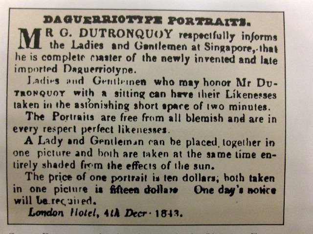
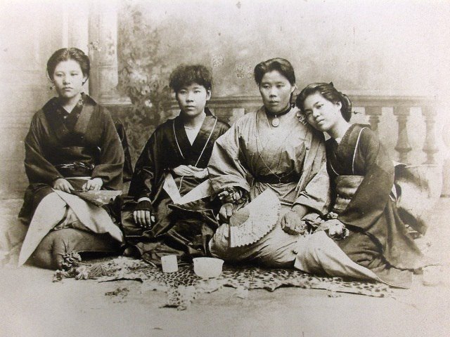
Just like the tale that Smith Street in Singapore Chinatown came from the corruption of the word Hokkien word si-mi-su ( 什么事), which means ‘ What is it?’ Cowan could be have originated from kawan.

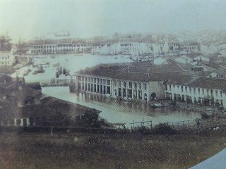
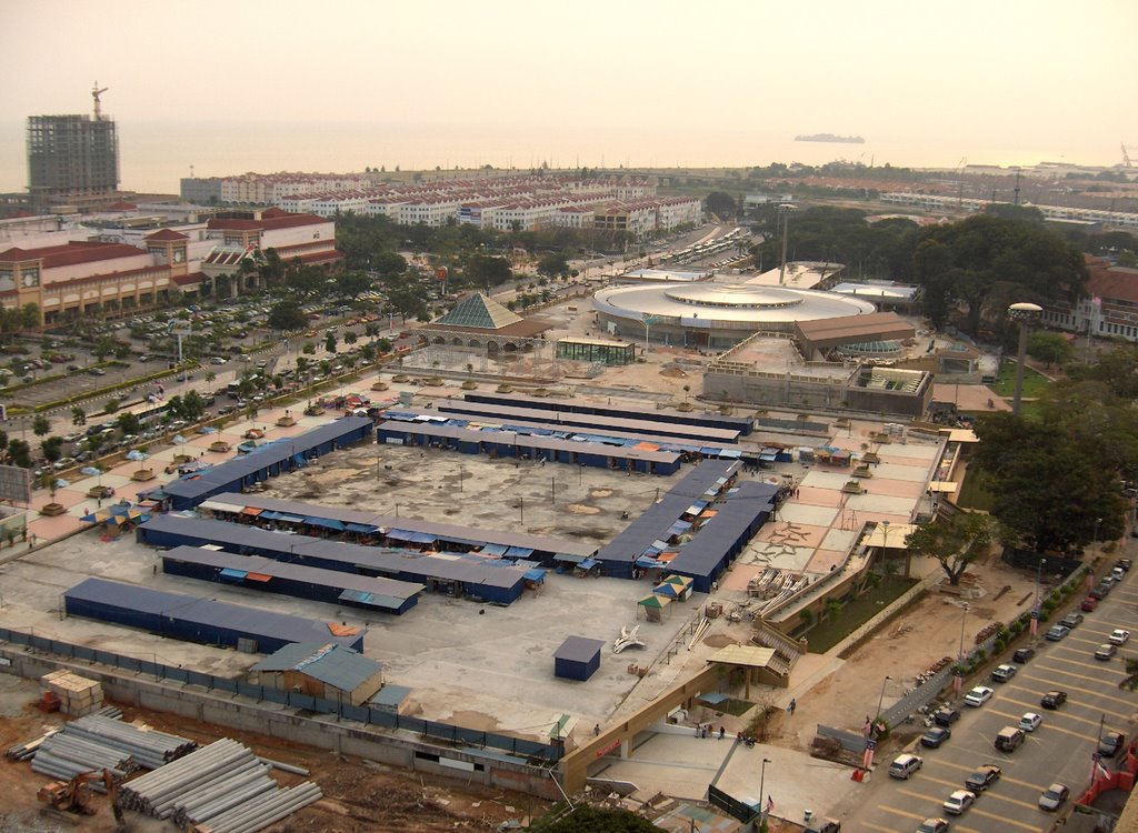
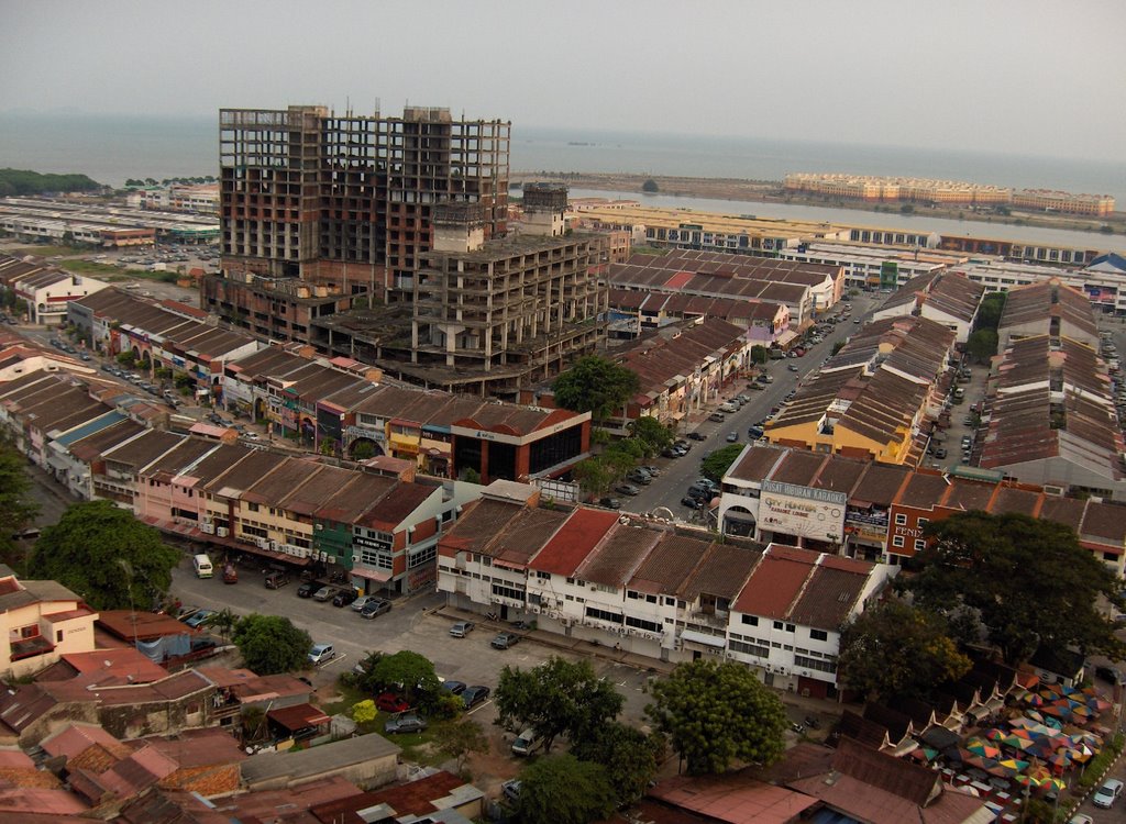
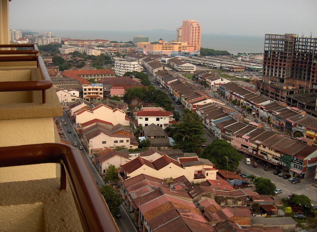
This aerial view photograph of Ipoh with Cowan Street in the middle was taken in 1962, when Ipoh became a municipality. The circular building known as the Yau Tet Shin Market or Bat Gog Lau (八角楼) in Cantonese is now gone. Itwas demolished not too long ago and what is left is a vacant lot. now. The complex to the mid-left is the Grand Cinema & Amusement Park. It was akin to the Great World City or Gay World of old in Singapore.

After the War Chew Choo Keng returned to Singapore, and with the capital he got from selling off his business in the peninsula, he started the Khong Guan Biscuit at Paya Lebar. As they say, the rest was history.


Post-script:

1. The Khong Guan story continues:

'During the Japanese occupation, cos Chew Choo Keng was unable to get flour for his business due to shortage, and refusing to use flour substitute, he dissolved the business.

He then went to Telok Anson to live with his father-in-law, and stared a soap making business. Business was good and he sold 400-500cases of soap per day. He soon became rich and with the money he made he started other businesses investing in coconut oil factory, rice trading company and salt company employing a few hundred workers.

The success of there trading activities boosted his confidence as a businessman and set the momentum for his gradual business expansion

During the war years in Telok Anson, the communist regarded him a traitor as he could drive his cars which served his company freely with permit from the Japanese military. He was arrested and interrogated by the communist in the jungle. It turned out later that the interrogator was a former female classmate of his in China. Chew met up with Chin Peng who instead of the charges, solicited his contribution to the communist cause, which involve usable products such as soap, salt, and oil as well as $10,000 cash. Upon his release, Chew was interrogated by the Japanese Military Police in Taping jail, on the events that took plaec in the jungle.

Chew in fact saw the war as a turning point, an opportunity to change his business venue from Malaya to Singapore. In the communist camp, Chin Peng warned him that Malaya would fight for its independence from the British, a revelation which started him thinking of going elsewhere for his business development.

Start-up in Singapore

Two months after the war, he returned to Singapore. He has sold all his businesses in Malaya for about $70-80,000. He was unemployed in Singapore and had spent about $10-20,000. He then ventured to start up the Khong Guan Biscuit Factory in Paya Lebar with the remainder of $50-60,000 as capita.'

2. In Singapore History Gallery of the newly opened National Museum of Singapore, Khong Guan Biscuits and the Chew brothers Choo Keng and Choo Han are featured in the Personal Path in the Merdeka zone on self-governing.


Reference:
1. Stepping Out –The making of Chinese Entrepreneurs, by Chan Kwok Bun, Claire Chiang, Prentice Hall 1994

2. Ipoh, The Town that Tin Built, A review of the history, progress and developmenet of Perak’s capital –commemorative book on the establishment of Ipoh as a municipality in on May 31, 1962. This book is availabe at the Middle Road National Library, Singapore.


-//-

Wednesday, December 06, 2006

the rice collection center - post war

The Chinese title of the map reads, from right to left - ‘An Abridged Map of Singapore City Area’ - 新加坡市区略图。It is a 60 year old map of the city - showing the government buildings and venues that were important & helpful to the travelers from China coming to Singapore.

This map was originally from a booklet of about 16 odd pages that provide information to travelers from China on immigration matters, conditions and way of getting around the city. What is left of this booklet is this map of Singapore that covers the center pages of 8 & 9, and the prints on the back of this map which is marked pages 7 and 10.

An interesting spot marked out on the map is the ‘Rice Card Collection Center’ – 米牌领取处 . The collection center was located next to the Government Offices - 政府公署, which is where the Asian Civilization Museum, Empress Place is now, and nearby the Social Welfare Department - 社会福利部, located close to the junction of the Singapore River and North Bridge Road - 小坡大马路.

The reason for the state of ration in the city - Rice Collection -and the process of getting a ration is clearly described in the section behind the map, titled Food Ration - 粮食配给.

It summary it states that there is a world wide grain shortage, and Singapore is affected by it too. It has therefore to implement the ration system. Without the ration card one will not be able to purchase rice and sugar. The ‘Rice Card Collection Center’ is located next to the ‘clock tower’. The process of obtaining a ration card is a simple one.

It also highlighted that the ration card is obtained for FREE and one will not need to pay any money to anyone for it. With the ration card one can go to the neighborhood rice merchant to purchase the allocated amount of rice/sugar at a controlled price. The retail shop should have the price of the items clearly tagged.

Reading thro the writings, one may ask - why the tone of caution and warning to the traveler to beware of paying for more for the card?

For, after the war, the world was gripped by a serious shortage of rice. Black market, a legacy of the Japanese Occupation continues to flourish. The British returned to Singapore and set up the BMA – British Military Administration, from Sep 1945 till April 1946. The BMA was dubbed the Black Market Administration (a). The social condition was chaotic. There was much to be done to put the society back into order, and to restock the shops with cheap and plentiful goods. Thus, the cautionary tone to the traveler on the ration card.


Post-script -

1. The traveler who got this map was traveling from China on his way back to Ipoh and passing thro Singapore the port of transit, in 1948.

2. Important buildings and venue marked are on the map:
Chinese Protectorate - 华民政务司
Social Welfare Department - 社会福利部
Labor Department - 劳工部
Government Offices - 政府公署
South Bridge Road - 大坡大马路 (Dapo Da malu)
New Bridge Road - 二马路 (Er malu)
City Hall - 市政局

Clifford Pier - 克利浦马头
Kallang Airport - 加笼飞机场

3. The Chinese Protectorate was formed in 1877 by the Colonial government to stem the abuse the new immigrants. If functioned until the outbreak of WWII. After the war its responsibilities was taken over by the Minster of Labor and Social Welfare, which is now the Minister of Manpower and Minister of Law.

4. South of the Singapore River to Chinatown is known as Dapo - 大坡, while the area from north of the river to Rochor is referred to as Xiaopo-小坡.

In the early 1800's the North & South Bridge Roads and the New Bridge Road were the major trunk roads running thro the city, and the local Chinese called them the Damalu -大马路 - the Main Road, and Ermalu - 二马路 - the Second Road

5. The airport was located at Kallang where the run was is where the National Stadium is.

6. The Embassy -总领事馆 located near 经禧路 –which is probably Cairn Road, should be the Embassy of the Republic of China.


Reference:

a. Singapore’s 100 Historic Places, National Heritage Board, 2004
b. A Sense of Independence – David Marshall - A Political Biography, by Chan Heng Chee, Times Book International c2001


-/--

Monday, November 27, 2006

the magistrate japanese stamp

This declaration letter was neatly type-written in English and is nearly 65 years ago. It was a declaration of ownership of a bicycle. To make it legal and binding, it also bore the officially stamped of the Stamp Office of Perak. Had it not been for the date and the other stamps on it, it would have been another court document from the British colonial period. However pouring thro the details, it unravels more than what that meets the eyes. It reveals an anachronism that could only be found in the history of that time.

For the document was issued in the name of the Nippon Government of Perak. It was declared before the Magistrate of Ipoh on the 3th of April 2602. The year was by the Imperial Calendar or Koki. After which the document was probably taken to the Stamp Office of Perak to be stamped, for the Stamp Office chop was dated 4th April and with the year 2602 written over the Gregorian year 19XX.

However there was a higher authority which the Nippon Government of Perak had to accede to and i.e. the - 军政部 / IPO机关 – Gunseibu IPO kikan – Military Department / Ipoh Operation. The stamp from the Military Department - Gunseibu - was ubiquitous on all documents and photographs from that era.

In addition to the two stamps above, the document also bears the stamp of the Magistrate. The stamp is faintly visible in the photograph, next to the Magistrate signature at the bottom of the page. What is unique and interesting about this stamp is that in addition to the Japanese Kanji / Katakana, it also has two lines of Arabic alphabets on it! The Arabic alphabets is Jawi Malay for ‘Pegadil, Ipoh’ which means ‘Judge, Ipoh’ written in the Malay language.

This document could only be a product of that era. A document issued by the Nippon Government of Perak based on the British Colonial law, stamped with a Magistrate chop in Japanese and Jawi Malay, and wetted thro by the Military Department. One ponders why the Jawi characters in the magistrate stamp and what subtle message was the Japanese military ruler sending to the local populace. Were there here as liberator instead of being the new master?

For the Japanese military, in order to win support for the wartime regime, held out promise of self-government to Sout-East Asians, and in a limited way involed the indigenous elite in the adminstration. It was the start of the new regime, and the use of the Jawi in the stamp could be a way for the new ruler to send this message thro - the building of the Greater East Asia Co-Proseperity Sphere - 大東亜共栄圏 Dai-tō-a Kyōeiken - " an attempt by Japan to create a self-sufficient "bloc of Asian nations led by the Japanese and free of Western powers".


Post-script:

1. The fall of Ipoh – 26th Dec 1941

This Boxing Day will be the 65th anniversary of the fall of Ipoh to the Japanese occupation force. On 25th Dec 1941, the last of the British forces destroyed all they could before leaving the town, and the following day, the 6th Division of the Japanese army marched into town. The force move continued its southward march and Singapore fell on Chinese New Year of 1942, Feb 15, about a month and half later.

2. The culture of – hanko - personal seal

The making of a person stamp is possibly kept alive nowadays in Chinatown because of the tourist trade. This tradition of keeping a personal seal, though is now mainly confined to the artistic community who practices Chinese calligraphy/ painting. In Japan, the culture of owning a hanko ( 判子) is still commonly practiced among the general population to this day. One can stamp a check using a hanko which bears one’s name.

3. Jawi Malay

Jawi Malay was commonly used among the Malay community before the introduction of Romanized Malay. It was used way back during Raffles day, for the treat which Raffles signed in 1819 with the Temenggong and the Sultan was also written in Jawi. The Hikayat Abdullah the autobiography of the Raffles Malay tutor was written in Jawi. And the National Museum has the original will of the Munishi, as Abdullah was honored as the learned one, written in Jawi Malay.

4. Detail of the declaration letter:

Nippon Government of Perak

FORM OF STATUTORY DECLARATION

I, Koo Kim Fan, residing in house No. 117 Main Road, Menglembu do solemnly & sincerely declare that I am the owner of a bicycle bearing number xxxxxxx 532288, During the war I evacuated to aplace of safety and in consequence I have mislaid the purchase receipt. I have not pledged the said receipt for the loan of money. AND I make this solemn declaration conscientiously believing the same to be true & by virtue of the provisions of the Statutory Declaration Enact 1899.

Subscribed & solemnly declared
By the abovenamed Koo Kim Fan
at Ipon this 3rd day of **il month
2602

Signature of declarant

Before me
Magistrate Ipoh

Sworn and interpreted by me,
Chinese interpreter Magistrate’s Court Ipoh


There are three stamps on the letter:

Stamp 1 – on top left corner

Stamp Office
-4April 19 2602
Ipoh


Stamp 2 - on top right corner

军政部 (Gunsei bu – Military Department)
2602 (year 2602)
IPO机关 (IPO Kikan – Ipoh Operation)
4-4 (date : 4th April)
PERA州支部 (PERA Shyu shibu – Perak State – sub branch)

Stamp 3 – bottom mid-left

KINTA郡 (Kinta Gun – Kinta District)
IPO裁判所长之印 (IPO Saibanshyochyo no in – The seal of the Head of Ipoh Magistrate court)
- jawi character – (Pengadil)
-jawi character – (Ipoh)


Note:
A) The Chinese characters are in Standard Chinese (PRC) and not in Japanese Kanji, due to computer/software limitation.
B) this was the same bicycle in the previous article in which the bicycle tax was paid.


Ref source:
http://www.diggerhistory.info/


/--

Wednesday, November 15, 2006

year 2605, bicycle tax & zero fighter plane

This receipt is a little more the size of a cinema ticket counterfoil, but the writing on it tells the story of a bygone era.

The receipt was for a Bicycle Licence and was issued on 24.3.05 by the Perak Police Chief under the Japanese Military Government. It is interesting to note that the date of the receipt, 24th March had the year counted as 2605, which was by reckoning of the Koki or Imperial calendar. This was equivalent to the Gregorian calendar 1945 or 20th year of Showa (昭和).

During the War years, the Koki calendar together with the Showa reign-year calendar of then Emperor Hirohito, was used in the territories occupied by the Japanese. Koki took its count from 660BC, the start of the reign of the mythical Emperor Jimmu, the first emperor of Japan. For it was said that to gain historical milestone and that Japan had as estemeed a pedigree as its ancient neigbours, the Koki calendar was adopted.

Shonan-to too was no different. The Gregorian calendar was abandoned, and the Koki/Showa calendar was promulgated across the land. Thus The Shonan Times, which was the renamed The Straits Times, had the year 1942 printed as Koki 2602 , Showa 17 .

A search on the web drew up much more interesting find on the Koki story -

Why was the famous Japanese fighter plane that dropped its bombs in Singapore on the early hours of 8Dec 1941 known as the Zero Fighter, (the Mitsubishi A6M ) ? For it was intimately connected to the Koki.

The last two digits of the Koki were used to date all military equipment up to 2599 i.e. year 1939. After that, only the single digit was used. The Mitsubishi A6M was adopted in the Koki year 2600,i.e. 1940, and thus named the Rei-shiki Sentoki (令式战斗机), in short Rei-sen (令战)or Zero Fighter. Zero being the last digit of the Koki year 2600.

The Koki calendar was abolished when the War ended. Though in Japan, the Emperor reign-year is still widely used by the population. This is the 18 year of Heisei (平成). The Heisei year began in 1989 when Emperor Akihito came to the throne. Heisie 1 is known as Heisei Gannen (平成元年).


Post-script:
1. Digging thro the pile of papers in the Made in Germany safe by Siemen’s Martin Steel, which guaranteed Fire & Burglar Proof, was this little receipt measuring 7.7cm by 9.6cm. It has been kept in the safe for the past 61 years and more.

2. The stamp on the top left hand corner reads:
军政部 (Gunseibu) – Military Department
260 - 260X
月 日 (getsu bi) - Month Day
产业部交通课 (Sangyobu kotsuka) - Industry Department, Traffic section
PERA州政厅 (PERA shyuseichyo) – Perak State Government


3. Details:
No. 263523
PERA州政厅 (PERA syuseichyo)

自转车许可证 (Jidenshyakyokasyo)
BICYCLE LICENCE

车体番号 (Shataibango)
Frame No. 532288

键札番号 (Kansatsu bango)
Plate No. 2933

自转车税 (Jidensha zei)
Registration Fee ……………/50 cts $1/-

键札料 (Kansatsu ryoo)
Plate Fee ………….../50 cts $5/-

发行日 (Hakkoonichi)
Date 24.3.05

PERA州警察部长 (PERA shyu keisatsubuchyoo) – Chief of Police, Perak State
PERAK


(Note: The Chinese characters used are Standard Chinese (PRC) and not Japanese Kanji.

4. The Registration and Plate fees were printed as 50cts, possibly in 1942 when the Japanese Military Government was established in Perak. Subsequently by 1945, the Plate fee had increased to $5/-, and inflation of 10 fold over a period of 3 odd years.


Ref:
1. http://www.warbirdforum.com/dates.htm


-//-

Wednesday, November 01, 2006

shots@ bonham hill - from daguerreotype to digital

The last two weekends was spent in the National Library pouring over books of old photographs and researching on when photography first came to the island.

It is deeply interesting to study what lies behind the old pictures be it the landmarks, geographical or man made or the people, and see how they have changed over the ages. It links us back to the past and gives us a sense of belonging to the place. Sadly to say, not much is left in the city of buildings that are over a century or more old, and the old photographs help fills the historical gap in our visual void.

Last Saturday, it was up Bonham Hill (aka Fort Canning) again, and this time was not so much to look for the fabled kings, but to check out the spots that where the photographers of old had taken those shots, and to ponder on the change. The photographs here were taken from Fort Canning overlooking the Singapore River across to Boat Quay and between them they span a period of over 160 years. And over photography has gone from daguerreotype to digital.

The picture above is said to be probably the earliest surviving photographic image of Singapore. It is a daguerreotype print taken in 1844 by Jules Itier, a Frenchmen. Itier was the head of a commercial mission to China and the Fart East. While on a stop over in the settlement he went around town to capture the touristy sight with his bulk camera.

Being a daguerreotype print the image is laterally inversed, and to view this picture in the proper perspective I had to look at the reflected image in the mirror. It then makes sense that the buildings in the fore ground on the left were probably a row of shop houses at the junction of Hill Street and North Boat Quay. The row of building behind it is the shop houses along Boat Quay on the opposite side of the Singapore.


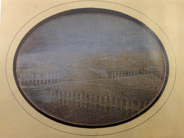
The photograph in the middle was taken by Sachtler & Co in 1863, and twenty years on with the wet collodion positive and collodion negative process photography improved by leaps and bound. The two bridges which were the predecessors of the Elgin Bridge and Coleman Bridge are clearly visible in the picture. In 1862, an iron bridge was imported from Calcutta to replace the wooden footbridge called the Thompson Bridge, and was renamed Elgin Bridge, after the Lord of the same name who was Governor-General of India, 1862-1863. Coleman Bridge spanning New Bridge Road is seen in the right lower corner of the photograph. The two rows of building in the middle is where the Riverwalk Apartment is now. These two storey shop houses have very prominent covered five footways in the shop front, and five foot ways was a building requirement laid out in the Jackson Town Plan.

The picture on the left was taken from the same vantage point on Fort Canning as the 2nd photograph. It was taken last on 28 Oct 2006, 12:11pm and as a 182kb JPG file take with a digital camera. Coleman Bridge is dwarfed by the high rise building around it, and a red double deck bus was just crossing it. The Singapore River is partly hidden by the trees planted along River Valley Road.

A picture tells a thousand words. It tells the past to the present, and the present to posterity. It has become a hobby of mine now to pour over old photographs, and it’s a habit of mine nowadays never to leave home without a camera, and a digital one for that.


Post-script :

1. Bukit Tuan Bonham or Bonham Hill was the Malay name for Fort Canning. It was named after Sir Samuel George Bonham, Resident Councilor from 1822 to 1836, then Governor from 1836-1848. In the later part of the 19th century it was called Bukit Bendara (Flag Hill) by the Malay. Prior to Raffles arrival, it was Bukit Larangan.

2. The daguerreotype was called the ‘mirror with a memory. ‘

3. The first commercial photographic advertisement appeared in the Singapore free Press.

“Mr G Dutronquoy respectfully informs the Ladies and Gentlemen at Singapore, that he is complete master of the newly invented and late imported Daguerreotype. Ladies and Gentlemen who may honor Mr Dutronquoy with a sitting can have their likenesses taken in the astonishing short space of two minutes. The portraits are free from blemish and are in every respect perfect likenesses. A Lay and a Gentleman can be placed together in one picture both are taken at the same time entirely shaded from the effects of the sun. The price of one portrait is ten dollars, both taken in one picture is fifteen dollars. One day’s notice will be required..
London Hotel, 4th December 843.”

London Hotel was located in High Street. Gaston Dutronquoy arrived in Singapore in March 1839 and it was recorded that he probably disappeared while prospecting for gold in Muar, 1857.

4. Lambert & Co
G.R. Lambert from Dresden opens photographic studio at 1 High Street, Singapore, 10April 1867. Became the premier photographer in Singapore spanning from 1870-1910 and left a wealthy collection of old photographs of SEA. Was the official photographer to the colonial government and the royal photographer to the King of Siam. Spanning the period 1908 to 1911, had in its employment as Assistant at least 3 Japanese national.

The photograph of the karayuki-san was taken by GR Lambert in 1890.

5. Lee Brothers
Premier Chinese Artists and photographers, 58/4 Hill Street, Singapore ca. 1910-1923; proprietor Lee Keng Yan, with photographic work undertaken by Lee Fook Heng.


Reference source:

1. A Vision of the Past
A History of Early Photography in Singapore and Malaya
The Photographs of G.R. Lambert & Co., 1880-1910
- By John Falconer; Times Edition 1987

2. Singapore, A Pictorial History 1819-2000
- By Gretchen Liu, National Heritage Board and Editions Didier Millet, 1999

3. From the Family Album
Portrait from the Lee Brothers Studio, Singapore 1910 – 1925
Introduced by Gretchen Liu, National Heritage Board, Landmark Book.

4. Singapore – A guide to buildings, Streets Places
-By Norman Edwards & Peter Keys, Times Book International 1988

5. http://en.wikipedia.org/wiki/Daguerreotype


/--

Monday, October 16, 2006

from amakusa to bugis junction

A hazy Sunday morning and though not as bad as it was last Saturday, the PSI reading was at near 100. I went in search of the place where the four Japanese girls in this postcard dated 1904, would have stayed when they were in Singapore. Why you may ask then, a postcard from Singapore would have featured the Japanese girls as its attraction.

It was early and the shops in the Bugis junction shopping mall, were not open yet and the ‘streets’ were quiet. The overhanging glass roof that protects the shopping mall from the weather did a good job to keep the haze out too. Except for the shop façade which exudes an air of colonial architecture with a straits flavor, one could have imagined this shotengai (商店街 – shopping mall) in Japan. Here you find Aji-sen noodle shop, the Kyoto-soba, and other Japanese restaurants.

The shopping mall is the first in Singapore to have a overhang structure which had borrowed the idea from the shyotengai in Japan. I heard that it was no coincidence, for the Japanese developer had wanted to develop the old shop lots in this area akin to the shopping mall in Japan For a century and more ago, this area was indeed called yat bun gai (Cantonese), jitpun goi (Hokkien) (日本街) by the locals. The young Japanese girls were karayuki-san who lodged in the brothels located here.

The story of the karayuki-san was a melancholy tale of young women leaving their impoverished villages in the south-western island of Kyushu (九洲) & venturing across the ocean to sell themselves to foreigners, in order to support their family back home.

The Japanese term karayuki (唐行), was originally to mean to travel to the Land of the Tang. As what our forefather would call their homeland Tangshan (唐山), the Japanese too referred to China as the Land of the Tang, as culturally the Tang Dynasty left the greatest imprint on Japan. However, from the mid-nineteen century onwards scores of young women from the poor farming and fishing villages of the Shimabara Peninsula and the Amakusa Island went abroad via the nearest port, Fukuoka, and karayuki took on a new meaning from then. And karayuki-san came to mean these women who left for foreign shores in China, Siberia, as far as India and Africa, and to South-east Asia.

The majority of these karayuki-san who came to Singapore stayed in the brothels in Xiaopo (小坡), west of the Singapore river - right at where Bugis Junction and the Intercontinental Hotel is located. A survey conducted in 1905, in the vicinity of Malay Street, Malabar Street, Hylam Street and Bugis Street counted 91 Japanese brothels, with close to 500 karayuki-san. These streets no longer exit per se, but are now part of the shopping mall. The area is bordered by Victoria Street & North Bridge Road to the north and south, and Middle Road and Rochor Street to the west and east.

At the turn of the 20th century, Singapore had a strong community of Japanese expatriates. When the 1917 Alien Registration Act was enforced, it recorded 1,805 males and 947 females. The majority of the female needless to mention were karayuki-san . The Japanese then called the Malay Street area, suteresu – a corruption of the English word street.


Post-script

1. In the layer of history of this area, this area was part of Kampung Glam, named after the Glam tree, whose bark was used in boat work. In Raffles town plan this area was designated a Bugis area. The Bugis were seasoned sea-fearers and brave warriors that roamed the seas of the Malay Archipelego for centuries and they originated from the Sulawesi Island. Subsequently the earliest immigrants from Hainan came & settled here (Hylam Street) and then the Japanese traders and the karayuki-san .


2. Other than the Malay Street vicinity, there were also a congregation of Japanese brothels in Chinatown , around Sago Street, Smith Street & Banda Street. Data from the 1905 survey of the Bugis area - the number of Japanese brothels and prostitues:

Street name - # of brothels - # of prostitutes
Hylam Street - 26 - 153
Malabar Street - 27 - 143
Malay Street - 32 - 179
Bugis Street - 6 - 23

In 1921, licensed Japanese brothels in Singapore were abolished.

3. The story of the karayuki-san was popularized in Japan by the novels of Yamazaki Tomoko – 'Sandakan no Hachiban Shokan' & 'Sandakan no Haka'. The author visited Singapore in the 1970’s and was sad to find that the shop houses were in a desolated state of abandonment. I’m not sure if Tomoko has visited the new Bugis Junction and what her impression would be now.

There are plates in the shopping mall describing the origins of the Bugis warriors who once settled in this area. However, there no longer is any trace of the karayuki-san, except in the names of the 'suteresu'. Wouldn’t it be good to have a plate too to remember them by, of their sojourn from Amakusa to Bugis Junction.


Reference:
Aku & Karayuki-san, Prostitution in Singapore 1870-1940 by James Francis Warren, published by Singapore University Press, 2003.


-//

Saturday, October 07, 2006

Atop mount Sophia overlooking bencoolen street

It seems a misty Saturday morning Oct 7, 2006, 7:55am - atop Mount Sophia., one could hardly see where Bencoolen Street and the NAFA and the surrounding buildings. If not for the smoky smell, one for a while would have thought Singapore had a Genting resort, & enshroud in the clouds. The haze is the worst so far. It was brought in by the south-westerly winds from the forest fire in Sumatra. With this haze coming in from Sumatra, Bengkulu is not so far off anymore.

Well near two centuries ago, when our Lady Raffles, whom this hill is named, traveled by sailing ship from Benkulu to Singapore it would have taken her a week and more to arrive here.

Bencoolen is the anglicized name of Bengkuku. It is located in south-west Sumatra on the same coastal front that bore the impact of 2004 Tsunami, with the ground zero Melebu located on the north-eastern end. In the days of sailing ship when the Suez canal was not open yet, ships sailing from Europe, round the tip of Africa, across the Indian Ocean to the far east, Bengkulu was a important port of call.

Sophia Hull married Stanford Raffles on 22Feb 1817, as his 2nd wife, at age 31, and him 37 years old. When she accompanied Raffles and started on her maiden voyage to Sumatra in Oct of that year she was already a Lady of the Knight. The ship that she sailed on was named after her, Lady Raffles. Raffles was earlier conferred the knighthood on 29 May by the Price Regent for his seminal work on The History of Java. He was on his way to take up the Lieutenant Governorship of Benkulu.

The journey by sea from England, round the Cape of Good Hope to Sumatra took five months. The ship anchored off Pulau Tikus, an island off Bengkulu in March 1818. In her letter she wrote that it was just after an earth quake & the houses were badly damaged the previous few days.

In the long journey, she gave birth to her first born whom she named Charlotte Sophia Tanjung Segara. (Lotus of the Sea). Why the Malay sounding name you may ask. For the latter name was given by the Java prince on board, Raden Raden Dipura. Raffles was appointed Governor of Java in 1811, and the price had traveled with him back England.

Sophia was an adventurous woman. Barely after she had settled on the island and regained herself from the sea sickness, she accompanied her husband to travel the interior of Sumatra, venturing into the Minangkabu territory. She wrote that the natives were so enthralled by the first white woman they saw, they thought she was some divine being. This travel of Raffles was published in The Globe and The Observer in mid January 1819.

Shortly after, she again joined Raffles on his journey to Calcutta, the HQ of the East India Company. They left on 2 September 1818 on the brig Udney, and arriving in Calcutta on 29September, Out of this trip was Raffles discussion with the Governor-General Lord Hastings on the establishment of a trading post on the southern tip of the Malay Peninsula to counter the Dutch threat to British trade interest in this south-eastern sea route between India and China.

On the return journey from Calcutta, Sophia and her husband de-toured to Pinang, The Prince of Wales Island, and reached there on 31December 1818. She stayed behind on the island while Raffles made his mission from there on board the Indiana that lead to the - founding of Singapore. While in Penang Sophia gave birth to her second child, a boy named Leopold Stanford.

She left Penang for Benkulu with Raffles on 22May, and sailing south, they called in at the new found settlement on the island of Singapore. This was her first trip to the island, a dense tropical jungle, with a outpost taking shape at the mouth of the Singapore River. In the four weeks when he was here and before he left on 28June, Raffles gave instructions to Lieutenant Colonel William Farquhar on the management of the new settlement.

Her second journey to Singapore was in September/October 1822 by which time the population on the island has grown to 5,000. She stayed till 9June1823 and in the 8 months she was here, Raffles has a wooden house build on Government Hill, aka Fort Canning or Bukit Larangan. In this trip Raffles laid forth the Singapore Town Plan which sets the foundation of the new settlement which is visible till today.


Post-script:

Lady Raffles Sophia, wrote the biography of Raffles in Memoir which was published four years after his death. As the saying goes, behind every successful man, is a woman. Sophia steadfastly supported Raffles in his days of adventure, joy and sorrow.

Raffles first wife was Olivia Fancourt, a widow ten years he senior whom he married in 1805 at the age of 25. She died in 1814 in Bogor as Lady Governess of Java. A marble monument erected by Raffles in her memory at the Botanical Gardens of Bogor stands till today.

History feels that Raffles has a greater love for Olivia, though his relationship with Sophia deepened over the years. By a strange coincident his marriages to Olivia and his second wife, Sophia, were for a similar period of nine years.


References:
Sophia Raffles by John Bastin, Landmark Books, c2002
Olivia Mariamne Raffles, by John Bastin, Landmark Books, c2002

Monday, September 25, 2006

Yes-ka, No-ka @ the bukit timah ford factory

The Sunday afternoon was spent doing some amateurish translation of the article, ‘Trial of Yamashita and Homma - A revenge drama’

‘All eyes of the world over were on the Manila Military Court on 7th Dec, 1945 (Showa 20 year). It was judgment day, and the first verdict on the trial of the Second World War criminal will be delivered. The person to be judged was General Yamashita Tomoyuki (picture). Yamashita was the general who demanded a ‘Yes or No’ answer from General Percival the British commander of the Allied forces in the fall of Singapore during the beginning of hostilities of the Greater East Asia War (or the Pacific War). He was also the general whom the Allied Forces notoriously named as the ‘Tiger of Malaya’.


The Yamashita trial was hastily convened on Oct 8th, immediately after the surrender of Japan. The five judges nominated by MacArthur, the Supreme Commander of the Allied Forces, by the way were all professional military personnel under him and they were utter green horns with regards to court trial. And it was not only that. All the legal proceedings of the court were decided by MacArthur himself.

Yamashita was prosecuted on the reason that he was the commander of the Japanese military that was engaged in the Manila Massacre, but to Yamashita it was something which he himself totally did not recall. In reality, no matter how many witnesses were filed, the evidence to link Yamashita to the massacre did not surfaced.

On the contrary, many of the people were impressed by the sincere attitude of Yamashita in court. When a questionnaire was conducted before the necessary delivery of judgment, with the twelve reporters from the different countries who were in attendance at the trial all twelve against none considered it not guilty. However the judge delivered a guilty verdict, and further it was death by hanging.

Next, on Dec 18th the same year, it was the commencement of the trial of Homma Masaharu. Homma was indicted as the person responsible for the ‘Bataan death march’.
In this incident after the fall of Bataan Philippines on April 1942 (Showa 17 year), about 7,000 of the captives in transportation died of hunger and malaria. This trial all in all was a copy of the Yamashita trial. In the case of Homma, the prosecuting attorney was not able to present a single evidence on – the massacre which single one of it was that he decreed or that he had knowledge of it.

On the contrary, in the transportation of the captives, Homma observed the international law and strictly decreed that his subordinates treat them with amity.

In actual fact, MacArthur harbored an intense vengefulness against Homma. Three years before, he was chased away from the Philippines by Homma, and that has inflicted the only scar in his brilliant military career. On Feb 11th of the following year, Homma was sentenced to death by shooting.

It is not overdone to say that in using the name of a court trial, the trials of Yamashita and Homma were MacArthur’s revenge dramas to make good his personal grudge.

‘No patriotic American is able to read the record of this trial without a sense of agony & be filled with shame that is hard to be erased.’ (Yamashita Trial)

These two very trials were the prelude to the Tokyo Tribunal.’


Post script -

It was a last minute shopping to grab something to read before boarding the plane at Narita Airport. This book titled ‘History that is not taught in the school textbook ‘at 500yen (SS6.50) inclusive 5% consumption tax, it’s relatively a bargain. But anyway, it states on the cover that this is a mass circulation edition – an edition meant to be circulated widely, and thus it is attractively priced, and should be easy to read too, I thought.

My attempt at the translation is to share with a wider audience, especially those who do not read Japanese what this book writes about the history that is not taught in the Japanese school textbook. Attempts have been made to re-write the history textbook in Japan and time and again it would result in escalation of protest from her neighboring countries. The articles in this book give an insight to what the Japanese, especially the conservative thinks.

The desire to translate this article was also prompted by an incident in a recent travel to Japan. While taking a cab in Tokyo, and when the cab driver came to know that I was from Singapore, he expressed his regret of the bad things that the Japanese military did here during the War and he apologized for what they did. It was quite an anomaly I thought, when their Prime Minister was making yearly visits to Yasukuni, where class A war criminals (according to the judgment of the International Military Tribunal of the Far East or the Tokyo Tribunal referred above) are enshrined, and you have this gentlemen apologizing the deeds of his elders to a stranger from ex-Shonan.

Any misinterpretation in the translation is purely of my shallow depth in the language . It is a language that I am fond of, and which I started learning many years ago.

This article prompted me to do a search in the web on Yamashita. After reading the article by George F Guy ‘The Defense of General Yamashita’, which was first published in the Wyoming Journal of Law in spring of 1950, my view on the notoriety of the ‘Tiger of Malaya’ could not be the same again. Guy was one of the defense counsel assigned to the defense of Yamashita. Yamashita was not a member of the mainstream military clique during the war, and he seemed an odd-man-out. Towards the end Guy wrote:

“I had talked with other Japanese officers of high rank who were arrogant, mean, bitter and resentful, but Yamashita, the man who must hang as the first proven example of
this new theory of international criminal law, was quiet, dignified and philosophical.”
- THE DEFENSE OF GENERAL YAMASHITAT.

The former Ford Factory in Bukit Timah Road where Yamashita demanded of Percival to surrender or not with the famous question ‘Yes-ka, No-ka?’ is now a museum dedicated to the history of the fall of Singapore and the war years.
http://www.nhb.gov.sg/NAS/NewsAndEvents/Ford+Factory.htm


/--

Monday, September 18, 2006

once upon a railway town

This map was taken from an exhibition of old postcards, maps and magazines organized by the Society of Japanese Culture. It is currently held at the Chinese Chamber of Commerce in Hill Street. What drew my interest to this map was that it showed the name of my hometown in Japanese! Though it was a small town, it was clearly marked and written as – MENGUREMUBU – in katakana.

This map was part of a large map published around 1943, that showed the occupied territory of MARAYA & SHONAN (照南) - Malaya and Singapore . When Singapore fell to the Japanese, the name was officially changed to SHONAN, meaning - Beacon of the South. The name SHONAN were in kanji (汉字)or Chinese character but rendered a kun-yomi (训读), that is reading the Chinese characters in Japanese style. All other town names were in katakana, one of the two types of Japanese alphabets, the kana’s – that is the katakata and hiragana.

Katakana is used chiefly for foreign words adopted into Japanese. Thus Menglembu was translated as MENGUREMUBU in katakana, and IPOH as IPOO (pronounced as I-POH, the OO denotes long sound). The character for ‘state’ was written in kanji, and Perak state was written PERAKU SHYU. The SHYU being a kun-yomi of 州。

I was also drawn to the railway lines on the map. Beside the main North-South line that ran thro Ipoh, there was another line that started from IPOO and ran in the south-west direction to TORONOO. In between these two terminals, the towns marked on this line were MENGUREMUBU and SHIPUTEN. It dawn on me that this was the railway line that mum used to talk about during dinner time. The line ran from Ipoh to Tronoh, and it had stations in Menglembu and Siputeh.

The older folks that lived during during the pre-WW II days had fond memories of this line. The station in Menglembu was located somewhere to where our old house was. The railway line crossed the trunk road on the northern part of the town. The town folks would refer to this part of the town as the Railway Gate – 火车闸. Being a town with a railway station would naturally have caught the Japanese map makers attention, and what more a town located in a stratetic tin mining region.

The British colonial masters had build a railway to link the booming tin mining town of Tronoh to Ipoh in the begining of the 20th century. This region was the centre of the tin mining industry industry.

The railway line was dismantled by the Japanese army during the Japanese occupation, and the older folks mentioned that the tracks were transported north to build the Thailand-Burma railway line. The Death Railway as it was popularly known was build with Japanese POW/s and countless forced labors from Malaya and Singapore.

What was then the railway track is now still visible in the town. It is now part of a straight trunk road that runs thro what is considered the rear side of the town. The road is named Jalan Lee Min Hin, after a towkay tin miner whose old masion is still standing beside the trunk road.

The tracks from this line contributed to the building of the infamous railway which was later made into box office Hollywood movie - The Bridge over River Kwai - in 1957, starring William Holden, and Jack Hawkins among its cast. The theme song from the movie - with the soldiers who build the bridge proudly whistling the tune as the marched across the newly completed bridge - was a hit during the 1960/s.


Side-note:

A search in the web on Tronoh, yielded the following:

Teronoh or Tronoh is a small tin-mining town located some 30 km south of the Perak state capital Ipoh in Malaysia.

The tin-mining industry boom during the early 20th century saw Teronoh grow from a small village into a major town. The centre of the mining field containing the mine of the Tronoh Mines Company, Ltd. was the village of Tronoh. The Tronoh Mines Company Ltd. belonged to Chung Thye Phin, a rich businessman (towkay) and last Chinese Kapitan of Perak and Malaya. It was here in Tronoh that Thye Phin's famous deep-shaft mine could be found.

A railway line linking the town and Ipoh was completed in 1909 and used to transport tin ore. The tracks were dismantled by the Japanese during World War II and were never rebuilt. Shortly after the war ended the tin industry deteriorated, and with it, the importance of the town.

Today Teronoh is a sleepy little town, though it is hoped that would change with the location of two universities within its vicinity - Universiti Teknologi Petronas and Universiti Teknologi MARA is located here. The main road that used to cut through town linking Ipoh with the seaside town of Lumut has been replaced by a new highway bypassing the town.

(Source: from Wikipedia, the free encyclopedia)


Friday, September 08, 2006

lat on fort canning & singapura golden era

The visit to Melaka St Paul’s hill, prompted me to make my way up Fort Canning last Saturday and went on the 14th Century walk.

A cartoon script on the hill by Lat tells the story of the first Golden Age of Singapore and the legendary sultanate of bygone years. The period lasted from the 1300/s to around 1400. The Singapura sultanate was the precursor to the Malacca sultanate.

(Note: Singapura or Lion City in Sanskrit; Malacca as a city name was official change to Melaka, but will continue to use Malacca as reference to the historic sultanate).

Colorfully depicted and vividly drawn with a touch of Lat’s humor, the carton brings alive legends from the Sejarah Melayu or the Malay Annals, - stories of how Singapura got its name; of Badang the strongman who hurled a big rock from the hill to the mouth of the Singapore river; of palace maiden bathing in the forbidden spring, supposedly located on the north-western side of the slope facing the River Valley swimming pool (closed since 2003) ; of attack of the sword fish on Tanjong Pagar; and of Tanah Merah or red earth, where an attack from the Majapahit army to right a wrong on a palace maiden, stained the land red with blood.

There too lies on the hill a keramat – a holy shrine – which was supposedly to be the grave of the last sultan of Singapura – Sultan Iskandar Shah

While volunteering as the docent of the Singapore History Museum & standing at Riverside Point overlooking Clarke Quay with the hill behind it, I would never fail to relate the legends of Bukit Larangan to the visitors, and bring them back 600 years before Raffles landed on the island in 1819. The sultan’s palace on the hill would over look a thriving port with ships from Arabia, India, China and around the archipelago.
Fast forward to the present, - a replica of the Raffles house now stands on the hill overlooking a soon to soar Integrated Resort on the bay. In the air is Mickey might be coming to town to join Lat’s cartoon characters.

/--


Monday, August 28, 2006

a tale of two cities - the historic link


These views of the historic town of Melaka were taken on the evening of 24Aug2006 from the 16th floor of Hotel Equatorial. On the right is St Paul’ Hill, & towards the left is Jalan Parameswara where the hotel is located. The greater part of the bay area is land reclaimed from the sea which is part of the Straits of Malacca. Coincidentally, Dataran Mahkota, with the round building compassed by the construction site towards the right was advertised in the Saturday’s Straits Times as an investment opportunity.

Imagine, half a millennium and more or so, out in the sea, this would had been a very busy port. From the late 14th century with the founding of the Melaka Sultanate and over next three centuries, Melaka the main port of call in South East Asia.

Atop St Paul’s hill is a statue of St Francis Xavier, the Jesuit priest whose memory is also enshrined in the park in Oita Japan. (St Francis Xavier & land of the Christian Daimyo) .Francis Xavier came with the Portuguese conquistadors with the mission of spreading the good news to the non-believers living in Cathay and Nippon. He stayed at the St Paul’s Cathedral atop the hill, where the hill is now named after. On his onward journey to the far east, Francis Xavier also mentioned in his notes that his ship stationed at the mouth of the Kallang River.. A copy of his notes could be seem at the Asian Civilization Museum, Elizabeth Place.

Before the Portuguese came Melaka, or Malacca till her name was officially changed, was the premier port of call in the Malay Archipelago and it was also where the Melaka sultanate began some 600 or more years ago. The Portuguese records had it that - ‘Parameswara a prince from the Sumatra royal house was fleeing from the Javanese masters. The ruler of Tumasik, Gamarajah welcome him. He was more interested in piracy than in trade. However he later murdered Gamarajah and took over the throne. The murdered ruler was a relative of the Thai overlord, who was angered and sought revenge on Parameswara. He escaped overland and founded another great city – Melaka’. (Source: the defunct - Singapore History Museum @ Riverside Point)

How closely is history intertwined and what it was eons ago maketh what we are today – as the saying goes 无古不成今 – without the past we would not have been what we are now. Tumasik, name of ancient Singapore before Sang Nila Utama set foot on this island and founded the Lion City, was the heart of the Singapura Sultanate 700years ago. It was a busy trading port with traders coming from Sung China, Arabia and from the regions.

As it is where a replica of the palace of the Melaka Sultanate is build on the foothill of the of St Paul’s hill near the mouth of the Melaka River, the palace of the Singapura Sultanate was located at Fort Canning or Bukit Larangan – the Forbidden Hill - near the mouth of the Singapore River. Singapura as a trading post faded into history after the murder of Gamarajah and the baton was passed on to Melaka.

The Melaka Sultanate was at its zenith in the early years of the 15th century. In 1405, the Ming Admiral Cheng Ho on its maiden maritime expedition – 郑和下西洋 - call at this port. There is a temple and a well named after Admiral Cheng Ho in the city. The expeditions also left behind a rich and unique legacy – the Peranakan, the Straits born culture. The peranakan cooking, the nyona delicatessen is very much a part of our daily food menu, and it has truly spiced up our lives.

Melaka fell to the Portuguese in 1511, and subsequently she was under the rule of the Dutch and then the British. When Raffles landed in Singapore in 1819, and rejuvenated the island that was in slumber for 600 years, the earliest batch of migrants that came to this island was the Peranakan’s from Melaka.


-//-

Monday, August 14, 2006

the gorgeous artist - xintiandi

A scene taken from Shanghai - Xintiandi, (新天地)4Aug06, Friday. 4:15pm.

This gorgeous artist was seated at the alfresco bar sketching the patio of the old mansion.
She was wearing a flowery bareback dress with spaghetti string, with a chic bracelet on her right hand, and had a nice make-up. Her lightly dyed hair was bundled up to expose a revealing mole on her shoulder. She seems engrossed in her work, but on second look, it seemed incongruous –wasn’t she overly dressed for her pastime. She didn’t look like a tourist, though.

Could she be from the local art school or the architecture college.? I didn't disturbed and asked her, though she would most probably have obliged with an answer. Anyway, she was dressed to her ninth, and would be heading to a party next after she finished her sketch. She was another sight to catch in addtion to the architectural gem in the the Shikumen (石库门) in Xintiandi.

The Shikumen in Xintiandi is described in the tourism brochure as ’a reflection of Shanghai historical culture in architecture, and a manifestation of the famous ‘Hai Stream’ civilization. (海派文化的集中体现). This is a touristy spot - like the Boat Quay in Singapore - a must for visitors to modern day Shanghai. Instead of merchant houses and godowns by the Singapore river, these were apartments build during the turn of the 20th century.

‘Hai Stream’ architecture is a uniquely Shanghai genre which has a blend of Shanghainese and western elements on the city architectural style as the city opened up to foreign influence. The equivalent in Singapore would be what the Straits architecture was.

Shanghai was one of the five ports opened to British trade by the Treaty of Nanking (1842) after China was humiliatingly defeated in the First Opium War. It prospered quickly and countries such as France, Great Britain, and the United States all held large concessions in the city until the early 20th century.


Nanjing Road (East)


One of the shops at the premier pedestrian shopping mall in China, Nanjing Road - the Orchard Road of Shanghai.


The ‘buaya’ looks familiar - Crocodiles for sale, in Lacoste green! As they say - one stone shoot two birds.


-//-

Saturday, July 08, 2006

uniquely Japanese - the Yamato discipline

This picture is taken outside the Oita station, and the person sweeping the sidewalk is a guard manning a building near the station. It’s early in the morning at 6:00am, and he had a broom and a bin with him sweeping up litters - cigarette butts and what have you. These little scenes of public spiritedness and discipline is still much the norm in this modern yet traditional society.

The Japanese is well known for its discipline and community spirit. Though, the majority of the population lives in cities, however beneath the veneer of modernity and high tech one finds a highly disciplined community of people who keeps their tradition and culture. A 20 minute by bullet train from the center of bustling Tokyo would take one to the outskirt where there are plots and plots of neatly cultivated rice fields. And in the midst of the fields and the farming community one would find the most modern high tech plant - making the chic digital camera.

Since its modernization drive in 1876 which began with the Meiji Restoration when Japan decided to open up to the world, it has absorbed the best of the west in hard sciences and continued to keep its tradition and culture. Over ther 130 years since, there runs in the society a symbiotic cord of modernity and tradition that is uniquely Japanese – a Yamato (大和) spirit of samurai discipline and an orderliness & perseverance nurtured by an agrarian society that often has to fend off earthquakes and typhoons.

Be it the rice fields or the state-of-the art high tech plants, they are run and managed by a people who is disciplined, orderly, and hierarchical. And out of discipline and orderliness is a society that produces your Lexus's, Cefiro's and Ixus's.


Sunday Mart - Shinjuku Central Park

If you know where to hunt, bargains are still available despite the exorbitant prices in Tokyo.

The Sunday morning mart beside the park in Century Hyatt Shinjuku. A dvd could be had for Y100 ($1.39)

Fertility shrine

A two and a half hour train ride from bustling Tokyo by the North-east Shinkansen takes you to a beautiful hot spring resort located in the mountain set amidst lush green rice fields (http://www.oosawaonsen.com/). Located in the hot spring is a fertility shrine revered by the locals.

Fertility shrines honoured in the Shinto style tradition. This shrine is decorated with white folded paper and a big rope made of rice straws hangs at the entrance. A smaller straw is draped around the object of veneration. Shinto shrine is made from wood which typifies nature, and usually set in the woods.

When Singapore was Shonan To during WW II, a huge Shinto was build in the woods in McRitchie Resvoir.

-//-

Wednesday, June 28, 2006

St Francis Xavier and land of the Christian Daimyo


St Francis Xavier at the invitation of the Christian Daimyo, Ootomosorin (大友宗麟)arrived in Oita in September 1551 to preach Christianity. Oita the capital of Oita Prefecture is located in the north eastern part of Kyushu island.

This statue of the Daimyo stands in front of the Oita train station.

St Francis Xavier was one of the earliest missionary to spread Christianity to Japan. On his journey to Far East the Jesuit priest wrote in his diary that he stopped over in Singapore, and the ship that he was traveling in docked somewhere out in the mouth of the Kallang river.

The Daimyo or feudal lords in Kyushu played an important role in Japan history and the introduction of western civilization to Japan. It was in the order of Lord Otomosorin that the 12 year old Ito-Don-Mansyo went to Rome to learn Christianity. This boy was the first Japanese to travel to Europe in the16th century. The feudal lords from this island also played a crucial role in modern Japan with the Meiji restoration in 1876.


This statue of St Francis Xavier is located in the park opposite the ruins of the castle in Oita.


ANA Hotel Oita Oasistower / 6:30am-JST

Monday, April 17, 2006

the expatriate artist

It was a Sunday morning on my usual routine. After gym headed down to Amoy street for my favourite changgen (肠粉) stall, after which a stroll thro the time tunnel thro Telok Ayer Street.

This stretch of road & the adjacent Amoy Street and Angsiang hill never fails to fascinate me, with its rich history - temples, mosques, clan associations - it has a never ending story to tell. The old shop houses have been reinvigorated. Where it used to be opium dens, you now have the lastest craze there - a yoga center.

As I was walking past, I saw a young man sitting in front of the shop lot, which is now a restaurant offering grandma's favourite cooking, absorbed in drawing the historical gem opposite him. I went over and chatted with him.

'Subarashii!' I said, meaing amazing in Japanese. He had on the postcard the side gate of the Thian Hou Temple beautifully outlined. He started off by sketching with his pencil, and drew the final in fine ink pen. I was amazed by the neatness and exactness of the drawing, and compared to what I've been sketching it was so much more professional.

He said that he is an expatriate architect from Japan. He had been sitting there for the past two and half hours since 10:30am drawing on the postcard. He said that he has been sketching since coming to Singpapore not so long ago, and showed me his master pieces in the sketch book that he had with him. It has the Shangrila Hotel, old shops in Bukit Batok where his condomium is, Wheelock Place, etc, all neatly draw. He said that he will touch up the drawings with colors and then send them as postcards back to his family in Tokyo.

I asked if I could take a picture of his drawing. He politely obliged and was very modest of what he has created, in the usual Japanese humbleness. He held up the picture for better lighting effect. I've met a number of foreign artists drawing the local scenes - historical & tourist sites -most of them are Japanese. They would draw in pen or pencil with and the sketch book as part of their travel gear. One of them commented to me that thro drawing he would be able to aborb the details of the building and site, and not just snap it with a camera. The local artists would usually paint in water color or in oil.

This encounter has brougt me new ideas and greater inspirations to draw. I could not wait to look forward to my next drawing session, and the weekend jouney thro history.


-/--

Saturday, April 15, 2006

a Good day for reflection

It was a cloudy Friday morning and traffic was smooth as it was a holiday. It was a holy day for the folks who go to church. When I saw them carrying palm leaves last Sunday, I realize that the Good day will be next, and was planning on what to do for the long weekend.

After breakfast I headed down to Hill Street. As the it was early and the gate was still locked, I had to climbed over the gates and sneaked into the compound of the Armenian Church.. In the quiet of the of the garden, I found a comfortable spot on the green an began my sketching.

Though there were no churchgoers to this 171 year-old church on this holy day, in the garden I saw some bronze statues depicting scenes of judgment by the Roman official, and of suffering bearing the heavy cross. It caused me to reflect and ponder this day of penance on some major world events, and other significant happenings.

In the West the clash of civilization is supposedly on the rise among the people of the Book. The latest find of the Gospel of Judas, though not a new revelation, has caused a stir among the holy community. Half way around the globe closer home and in the supposedly heaven on earth city of Hangzhou a milestone event is going on. It was the first time since the communist rule came to power in 1949, that a religious forum was organized by the religious communities on both sides of the straits, and sanctioned by the mainland government. Participants came from 34 countries world wide - from both the academic and religious organisations. Be the event to put the communist party in a better light, the dharma wheel is set into motion again in this ancient land, and a hope for peace in diversity.

It started to drizzle a little, and the stomach said that it was time for lunch. After a three hour sitting on the green the legs were all numb, and it jerked me back into the real world. It was a meaningful morning spent. I had the church in my sketch book to take home to adorn the wall.


-//-

Friday, March 17, 2006

the mountatin resort above the valley

The distance from Ipoh to Tanah Rata using the highway off Simpang Pulai is about 95km odd, and it took me an hour and half to reach there. This stretch of highway opened a few years ago, and it has halved the distance to the resort by traveling the old road from Tapah.

The highway up the mountain is wide and less winding than I had expected. The drive was pleasant, and there was not may steep climb along the way. Though certain sections of the roads were very close the mountain slopes and a stretch of it was under re-construction because of a landslide.
At the junction at Kampong Raja, one turns right turn, and soon will reach the resort proper with Brinchang at the highest township at over 1,600m. Traveling by the old road and heading from the south from Tapah, one would reach Ringlet, then Tanah Rata and then up to Brinchang. However, driving from the north will lead you straight to Brinchang.

The three townships make up what is popularly known as Cameron Highlands. It is named after William Cameron, a British surveyor who stumbled across the highland plateau on a mapping expedition in 1885.

The journey up was a pleasant morning drive and there were only a few cars on the road. It was a fine day and stretches of road was enveloped by the morning fog. The misty mountain air gave one the feeling of being in a dream like world. The view was spectacular, and it’s exhilarating to be in the folds of the mountain.

The air got cooler as one climbed higher. One could see Orang Asli (natives) settlements on the hill slopes. I saw them from the highway, carrying long poles which could be blow pipes and heading for their morning hunt. The Orang Asli’s in this part of the peninsular are mainly from the Senoi tribe. Originally they were thought to have come from the hills in Vietnam, Cambodia or Northern Thailand, about 6000 - 8000 years ago.

(photo: these two orang asli kids were playing in the stream in the golf couse at Tanah Rata. They spoke a language which is alien from Malay. The dad was caddying and they have a care free time in the open. When I asked to stand togehter to have their picture taken, the taller of the two kids asked me for RM10. Hindsight I should not have given them each with RM5)

As on drove further up, vegetable farms, orchards and tea plantations came into view. One could stop to shop for fresh vegi, flowers or enjoy a cup of Cameroonian tea outdoor with the tea plantation in the backdrop.

Little did I realize that later when I reach the resort proper the road was chocked with traffic. Cars were crawling bumper to bumper along the narrow mountain road. As it was the 3rd day of the long CNY break, car loads of family members were up on the resort for the holiday break.

All in, it was a good trip up the mountain resort after a break of more than 20 years. With the new highway, the mountain resort is easily accessible from Ipoh. However a word of advise - never to go up the resort during festive holidays. The traffic jam could not be worse.


Tea plantation next to the highway, berfore Kampung Raja driving from Ipoh. It is open to public and the tea house serves tea in an open terrace overlooking the plantation.


-//-

Wednesday, March 15, 2006

the origin of the sandy river noodles

Last Saturday was at the Hong Lim Food Center, patiently joining the long queue of customers for a taste the Ipoh Sar Hor Fun. Though it is Ipoh Sar Hor Fun, the dish is prepared far from the way it is done in Ipoh.

The noodles could be prepared in a variety of ways, and the most popular way done in Ipoh is to serve it in soup. The rich chicken & prawn stock has a thin layer of prawn oil on it that gives the white noodles a pleasant orangey look. It is topped with shreds of chicken and prawn meat and a sprinkling of chives (韭菜) . This method of preparing the dish is very different from the way it’s done at the stall in Hong Lim Food Center, which it is served dry in gravy and one could order it with crayfish and prawns, chicken and prawn meat, etc.

Why then is it named Ipoh Sar Hor Fun? This is because the rice noodle from Ipoh is reputed to be the smoothest, and this had to do with the water use for making the noodles. Its source is from the limestone hills that surround the valley town. Since then, the reputation of the noodle has spread far and wide.

Interestingly the name Ipoh - Sar Hor Fun (沙河粉) in actual fact is a composite of the names of two towns as its prefix, namely Ipoh and Sar Hor (沙河). Where then is Sar Hor?

We’ll many years back on my first trip to Guangzhou, China; I took land route from Hong Kong to the city. As the coach approached Guangzhout city proper, I saw a signboard with the word Sar Har (沙河)written on it. As the name in Chinese is the same as the Sar Ho - Fun back home, it triggered my curiosity. On inquiring, lo and behold!, I was told that this area is famous for it noodles. The name Sar Ho literary means Sandy River, and probably there was a river by this name that flows nearby. It then dawned on me that this place is the mother of all the Sar Ho Fun’s.

The early migrants brought with them the method of making Sar Hor noodle to Ipoh. And as they said the rest became history.

Interestingly, as the Ipoh Sar Hor Fun at Hong Lim Food Center grew in fame, it’s style of cooking could be imitated by other stalls and they would then adopt the name Hong Lim Ipoh Sar Hor Fun……Well, isn’t the Sar Hor Fun really fun!


The original Ipoh Sar Ho Fun ( 天津茶室, 怡保)


Hon Lim Complex - Tuck Kee (Ipoh) Sar Ho Fun


-//-

Friday, March 10, 2006

a splashing sliding time in nutty town

Some time back in the autobiography of Frank Swettenham (Governor of Straits Settlement 1901-03) I read that he had visited the tin mining areas of Lahat and Pusing. The towns are located at the foothill of the Kledang range in the late 1800’s. (dawn in the year of the dog) . He was told that there were many waterfalls and steams around the area and the local folks would have picnics and enjoy ‘mengeluncur’ in the falls.

The Malay word ‘megeluncur’ means ‘to slide’ and most probably the folks had a splashing time sliding down the waterfalls and bathing in the cool mountain streams.

When asked where they were heading too, the local folks could have answered ‘Mengeluncur’, and subsequently it could have got evolved into Menglembu.

We’ll this is purely my own conjecture and hypothesis on how my hometown got its name. As it also sounded ‘lumpur’ or ‘lembu’, it could have been a muddy place or a place where cows once roam. The former seems unlikely as it was located at the foothill and the soil is hard and the river rocky and not a place to find muddy and soft ground. It is not early day Kuala Lumpur, which began life at the muddy confluence of the Klang & Gombak Rivers.

As to the name of the town linked to ‘lembu’ or cow, the early immigrants could have kept cows. In the early days, there was a community of Indians/Punjab who reared a big herd of cows near the foothills. In the morning and evening they would let the cows roam the foothills to feed on the grass. We used to order fresh milk from them. The milk was delivered in the F&N glass bottle. Each morning mum would boiled the milk and we;’ll have a glass for breakfast before heading to school.

As to why meng-lembu, I wonder why then would one want to make it an active verb with the prefix ‘meng’ connected to ‘lembu’. There are places that is named after cows such as Kandang Kerbau, (buffalo shed), but Meng-lembu seems not likely to have anything do to with cows.

Could it be a name of a fruit or a three which I have not heard of, a local term for a animal? I have yet to find out. But for now, I will keep to ‘mengeluncur’ as it sounds the closet to Menglembu, and the town next to it seems to suggest this is so.

Further south along the range about 3km away is the town Pusing. It is located much near to the foothill, and the word ‘pusing’ in Malay means to turn around as in direction.
Pusing is located right at the foothill, and if one does not intend to climb the hill, he’ll have to make a U-turn back.

The locals would have gone to the hill ‘mengeluncur’ , have fun sliding in the waterfall, and on reaching the end of the range, ‘pusing balek’, and turn back to return home.

During the Japanese occupation in the 1940’s Pusing wa a important gateway for the Anti-Japanese guerillas to their jungle hide-out. The WW II hero, Lim Bo Seng and his fellow 136 infiltrators would have visited the town. The SBC tv drama ‘The Price of War’, had the location in Pusing, casting of James Lai, as the war,hero.

Menglembu, being small town, I was in doubt if I could find its name in the web. Well, to my big surprise, its name appeared as the world renowned - Menglembu Groundnuts! (nutty)

It was no wonder that a few years back the Ipoh Municipal Council built a big & unsightly model of the groundnut at the northern entrance to the town. They should have been more imaginative and considered a Big Splash instead.


friendly folks! nutty coconuts!

update: 15Mar2006

It could not have been more coincidental. After this blog was written, I laid my hand on the Coffee Table Book published by the Perak Academy, ‘Kinta Valley, Pioneering Malaysia’s Modern Development’, and it helped answered the question that had always been on my mind – how Menglembu got its name.

In the book there was a chapter on Kinta Towns, and an article on Menglembu. It read ‘It is possible that “Menglumbu-Tekah, was originally a pastoral area. Tekka means a Muslim prayer-house and Menglembu probably refers to cattle-herding carried out by Pahan migrants from Afghanistan...'. It now seems that ‘lembu’ is the more likely the hypothesis for the origin of the town’s name.

The Pusing town mentioned above should have been Papan. Sybil Karthigasu, the WW II heroine of Ipoh, had her clinic there. The town was also visited by Sir Cecil Clementi Smith in 1889, which indicated its importance as a center for tin mining activities then. Papan started off as a logging town, where the Malay word means plank. It was one of the oldest towns in the Kinta valley where the Chinese community migrated. In what the book called Papan a cul-de-sac town, it is now a quite and desolated town. When the tin industry collapsed in the 1980’s, the large number of the young folks went to Japan, or re-migrated to the US, in search for jobs.

As to how Pusing got its name, the book wrote, ‘The place was named Pusing because there was a lotus pond (kolam teratai). So the water was used by them to wash the ore. The waster was turned around and channeled back into the pond and re-used’.

The book was sold at the Perak Meili (Beautiful) 2006 Singapore Exhibition at the Grand Copthorne Waterfront Hotel. The fair was on for a day 14March2006.

.

.

-//-