Friday, March 17, 2006

the mountatin resort above the valley

The distance from Ipoh to Tanah Rata using the highway off Simpang Pulai is about 95km odd, and it took me an hour and half to reach there. This stretch of highway opened a few years ago, and it has halved the distance to the resort by traveling the old road from Tapah.

The highway up the mountain is wide and less winding than I had expected. The drive was pleasant, and there was not may steep climb along the way. Though certain sections of the roads were very close the mountain slopes and a stretch of it was under re-construction because of a landslide.
At the junction at Kampong Raja, one turns right turn, and soon will reach the resort proper with Brinchang at the highest township at over 1,600m. Traveling by the old road and heading from the south from Tapah, one would reach Ringlet, then Tanah Rata and then up to Brinchang. However, driving from the north will lead you straight to Brinchang.

The three townships make up what is popularly known as Cameron Highlands. It is named after William Cameron, a British surveyor who stumbled across the highland plateau on a mapping expedition in 1885.

The journey up was a pleasant morning drive and there were only a few cars on the road. It was a fine day and stretches of road was enveloped by the morning fog. The misty mountain air gave one the feeling of being in a dream like world. The view was spectacular, and it’s exhilarating to be in the folds of the mountain.

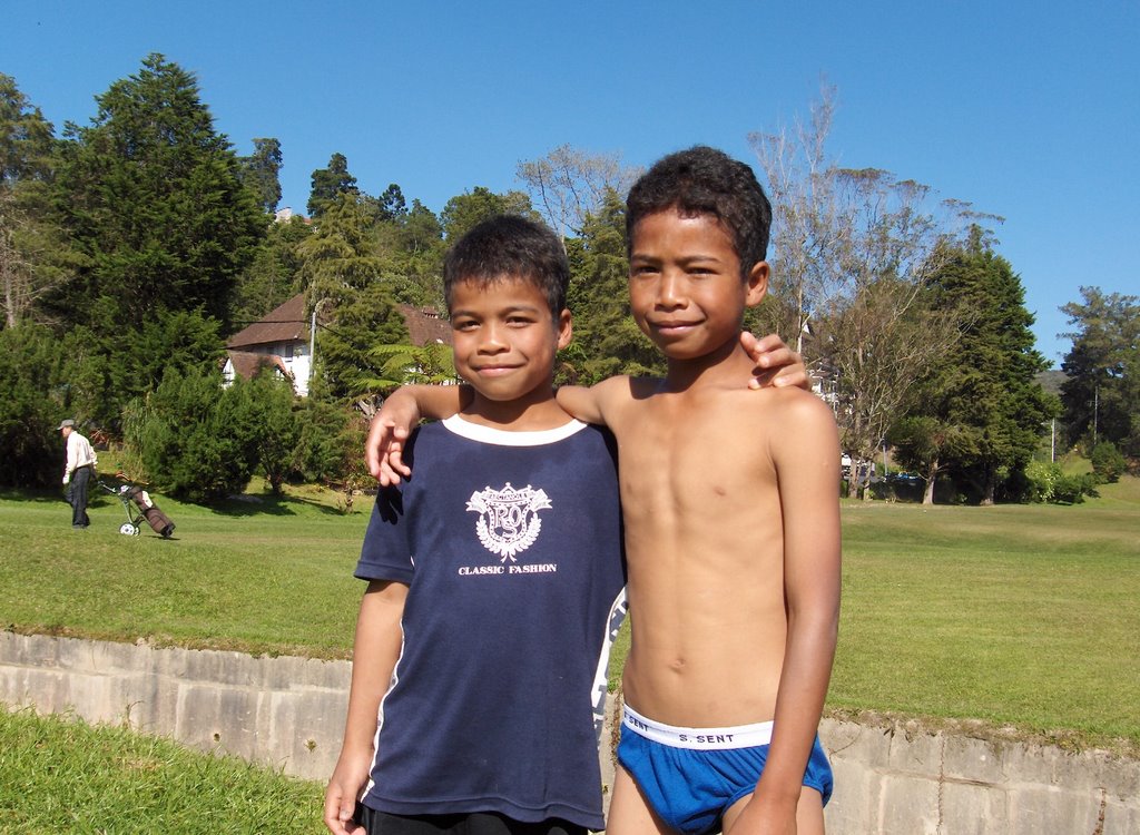
The air got cooler as one climbed higher. One could see Orang Asli (natives) settlements on the hill slopes. I saw them from the highway, carrying long poles which could be blow pipes and heading for their morning hunt. The Orang Asli’s in this part of the peninsular are mainly from the Senoi tribe. Originally they were thought to have come from the hills in Vietnam, Cambodia or Northern Thailand, about 6000 - 8000 years ago.

(photo: these two orang asli kids were playing in the stream in the golf couse at Tanah Rata. They spoke a language which is alien from Malay. The dad was caddying and they have a care free time in the open. When I asked to stand togehter to have their picture taken, the taller of the two kids asked me for RM10. Hindsight I should not have given them each with RM5)

As on drove further up, vegetable farms, orchards and tea plantations came into view. One could stop to shop for fresh vegi, flowers or enjoy a cup of Cameroonian tea outdoor with the tea plantation in the backdrop.

Little did I realize that later when I reach the resort proper the road was chocked with traffic. Cars were crawling bumper to bumper along the narrow mountain road. As it was the 3rd day of the long CNY break, car loads of family members were up on the resort for the holiday break.

All in, it was a good trip up the mountain resort after a break of more than 20 years. With the new highway, the mountain resort is easily accessible from Ipoh. However a word of advise - never to go up the resort during festive holidays. The traffic jam could not be worse.


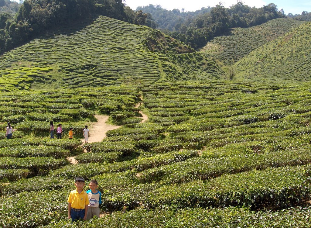
Tea plantation next to the highway, berfore Kampung Raja driving from Ipoh. It is open to public and the tea house serves tea in an open terrace overlooking the plantation.


-//-

Wednesday, March 15, 2006

the origin of the sandy river noodles

Last Saturday was at the Hong Lim Food Center, patiently joining the long queue of customers for a taste the Ipoh Sar Hor Fun. Though it is Ipoh Sar Hor Fun, the dish is prepared far from the way it is done in Ipoh.

The noodles could be prepared in a variety of ways, and the most popular way done in Ipoh is to serve it in soup. The rich chicken & prawn stock has a thin layer of prawn oil on it that gives the white noodles a pleasant orangey look. It is topped with shreds of chicken and prawn meat and a sprinkling of chives (韭菜) . This method of preparing the dish is very different from the way it’s done at the stall in Hong Lim Food Center, which it is served dry in gravy and one could order it with crayfish and prawns, chicken and prawn meat, etc.

Why then is it named Ipoh Sar Hor Fun? This is because the rice noodle from Ipoh is reputed to be the smoothest, and this had to do with the water use for making the noodles. Its source is from the limestone hills that surround the valley town. Since then, the reputation of the noodle has spread far and wide.

Interestingly the name Ipoh - Sar Hor Fun (沙河粉) in actual fact is a composite of the names of two towns as its prefix, namely Ipoh and Sar Hor (沙河). Where then is Sar Hor?

We’ll many years back on my first trip to Guangzhou, China; I took land route from Hong Kong to the city. As the coach approached Guangzhout city proper, I saw a signboard with the word Sar Har (沙河)written on it. As the name in Chinese is the same as the Sar Ho - Fun back home, it triggered my curiosity. On inquiring, lo and behold!, I was told that this area is famous for it noodles. The name Sar Ho literary means Sandy River, and probably there was a river by this name that flows nearby. It then dawned on me that this place is the mother of all the Sar Ho Fun’s.

The early migrants brought with them the method of making Sar Hor noodle to Ipoh. And as they said the rest became history.

Interestingly, as the Ipoh Sar Hor Fun at Hong Lim Food Center grew in fame, it’s style of cooking could be imitated by other stalls and they would then adopt the name Hong Lim Ipoh Sar Hor Fun……Well, isn’t the Sar Hor Fun really fun!


The original Ipoh Sar Ho Fun ( 天津茶室, 怡保)


Hon Lim Complex - Tuck Kee (Ipoh) Sar Ho Fun


-//-

Friday, March 10, 2006

a splashing sliding time in nutty town

Some time back in the autobiography of Frank Swettenham (Governor of Straits Settlement 1901-03) I read that he had visited the tin mining areas of Lahat and Pusing. The towns are located at the foothill of the Kledang range in the late 1800’s. (dawn in the year of the dog) . He was told that there were many waterfalls and steams around the area and the local folks would have picnics and enjoy ‘mengeluncur’ in the falls.

The Malay word ‘megeluncur’ means ‘to slide’ and most probably the folks had a splashing time sliding down the waterfalls and bathing in the cool mountain streams.

When asked where they were heading too, the local folks could have answered ‘Mengeluncur’, and subsequently it could have got evolved into Menglembu.

We’ll this is purely my own conjecture and hypothesis on how my hometown got its name. As it also sounded ‘lumpur’ or ‘lembu’, it could have been a muddy place or a place where cows once roam. The former seems unlikely as it was located at the foothill and the soil is hard and the river rocky and not a place to find muddy and soft ground. It is not early day Kuala Lumpur, which began life at the muddy confluence of the Klang & Gombak Rivers.

As to the name of the town linked to ‘lembu’ or cow, the early immigrants could have kept cows. In the early days, there was a community of Indians/Punjab who reared a big herd of cows near the foothills. In the morning and evening they would let the cows roam the foothills to feed on the grass. We used to order fresh milk from them. The milk was delivered in the F&N glass bottle. Each morning mum would boiled the milk and we;’ll have a glass for breakfast before heading to school.

As to why meng-lembu, I wonder why then would one want to make it an active verb with the prefix ‘meng’ connected to ‘lembu’. There are places that is named after cows such as Kandang Kerbau, (buffalo shed), but Meng-lembu seems not likely to have anything do to with cows.

Could it be a name of a fruit or a three which I have not heard of, a local term for a animal? I have yet to find out. But for now, I will keep to ‘mengeluncur’ as it sounds the closet to Menglembu, and the town next to it seems to suggest this is so.

Further south along the range about 3km away is the town Pusing. It is located much near to the foothill, and the word ‘pusing’ in Malay means to turn around as in direction.
Pusing is located right at the foothill, and if one does not intend to climb the hill, he’ll have to make a U-turn back.

The locals would have gone to the hill ‘mengeluncur’ , have fun sliding in the waterfall, and on reaching the end of the range, ‘pusing balek’, and turn back to return home.

During the Japanese occupation in the 1940’s Pusing wa a important gateway for the Anti-Japanese guerillas to their jungle hide-out. The WW II hero, Lim Bo Seng and his fellow 136 infiltrators would have visited the town. The SBC tv drama ‘The Price of War’, had the location in Pusing, casting of James Lai, as the war,hero.

Menglembu, being small town, I was in doubt if I could find its name in the web. Well, to my big surprise, its name appeared as the world renowned - Menglembu Groundnuts! (nutty)

It was no wonder that a few years back the Ipoh Municipal Council built a big & unsightly model of the groundnut at the northern entrance to the town. They should have been more imaginative and considered a Big Splash instead.


friendly folks! nutty coconuts!

update: 15Mar2006

It could not have been more coincidental. After this blog was written, I laid my hand on the Coffee Table Book published by the Perak Academy, ‘Kinta Valley, Pioneering Malaysia’s Modern Development’, and it helped answered the question that had always been on my mind – how Menglembu got its name.

In the book there was a chapter on Kinta Towns, and an article on Menglembu. It read ‘It is possible that “Menglumbu-Tekah, was originally a pastoral area. Tekka means a Muslim prayer-house and Menglembu probably refers to cattle-herding carried out by Pahan migrants from Afghanistan...'. It now seems that ‘lembu’ is the more likely the hypothesis for the origin of the town’s name.

The Pusing town mentioned above should have been Papan. Sybil Karthigasu, the WW II heroine of Ipoh, had her clinic there. The town was also visited by Sir Cecil Clementi Smith in 1889, which indicated its importance as a center for tin mining activities then. Papan started off as a logging town, where the Malay word means plank. It was one of the oldest towns in the Kinta valley where the Chinese community migrated. In what the book called Papan a cul-de-sac town, it is now a quite and desolated town. When the tin industry collapsed in the 1980’s, the large number of the young folks went to Japan, or re-migrated to the US, in search for jobs.

As to how Pusing got its name, the book wrote, ‘The place was named Pusing because there was a lotus pond (kolam teratai). So the water was used by them to wash the ore. The waster was turned around and channeled back into the pond and re-used’.

The book was sold at the Perak Meili (Beautiful) 2006 Singapore Exhibition at the Grand Copthorne Waterfront Hotel. The fair was on for a day 14March2006.

.

.

-//-